
Synchronising the Hydraulics Model Builder and NDWI Indexes in Remote Sensing Techniques to estimate accurate Flood Hazard from Satellite Images
DOI:
https://doi.org/10.58564/IJSER.5.3.2026.372Keywords:
Al-Shirqat region, Water resources, Flood hazard, Landsat 8 OLI, (HDM)Abstract
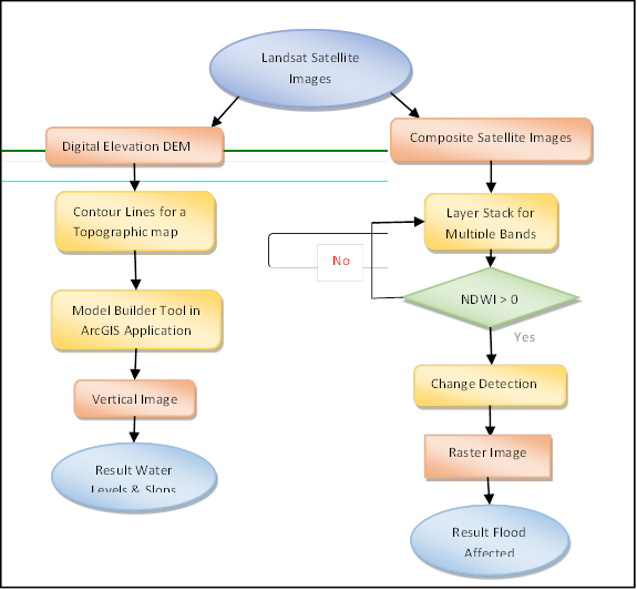
Water resources are an important natural resource that sustains life and supports the growth of society and an economy. However, it remains an unusual resource that is not always available at the same time or in the same place. Climate change and global warming have worsened extreme weather events, such as heavy rain and flooding, in many parts of the world over the last few decades. This study aims to identify and map regions in Al-Shirqat at risk of flooding through analysis of Landsat 8 OLI data. A Hydraulics Model (HDM) was a distinct structural modelling tool within the ArcGIS environment that utilised the Python programming language to compute water depths from Digital Elevation Model (DEM) data. This suggested method improves standard analytical methods, which involve analysing images for the Normalised Difference Water Index (NDWI). This study’s findings offer a pragmatic approach for enhancing flood risk evaluation and water resource management in analogous geographical contexts.
References
[1] P. A. Brivio, R. Colombo, M. Maggi, and R. Tomasoni, ‘Integration of remote sensing data and GIS for accurate mapping of flooded areas’, Int. J. Remote Sens., vol. 23, no. 3, pp. 429–441, Jan. 2002, doi: 10.1080/01431160010014729.
[2] M. Safaripour, M. Monavari, M. Zare, Z. Abedi, and A. Gharagozlou, ‘Flood Risk Assessment Using GIS (Case Study: Golestan Province, Iran)’, Polish J. Environ. Stud., vol. 21, no. 6, pp. 1817–1824, 2012, [Online]. Available: https://api.semanticscholar.org/CorpusID:15377812
[3] [3] R. Mukhaiyar and U. Mukhaiyar, ‘Attributes Classification for Elaborating the Information of Digital and Imaging Mapping’, JOIV Int. J. Informatics Vis., vol. 8, no. 3–2, p. 1545, Nov. 2024, doi: 10.62527/joiv.8.3-2.2353.
[4] Purwadi, N. A. Abu, O. Mohd, B. A. Kusuma, and A. Ahmad, ‘A Slab Multi-Fold Classification Technique on A Mixed Pixel Hyperspectral Image’, JOIV Int. J. Informatics Vis., vol. 9, no. 5, p. 2192, Sep. 2025, doi: 10.62527/joiv.9.5.3432.
[5] P. Razi, A. Putri, J. T. Sri Sumantyo, and - Akmam, ‘Vulnerability Liquefaction Mapping in Padang City Based on Cloud Computing Using Optical Satellite Imagery Data’, JOIV Int. J. Informatics Vis., vol. 8, no. 3–2, p. 1932, Nov. 2024, doi: 10.62527/joiv.8.3-2.3480.
[6] A. H. Musarhad, M. J. Farhan, and A. A. Khalaf, ‘Evaluation of the Fertility Status of some Soil Series of the North Tikrit Agricultural Project using Geospatial Technologies’, IOP Conf. Ser. Earth Environ. Sci., vol. 1158, no. 2, p. 022032, Apr. 2023, doi: 10.1088/1755-1315/1158/2/022032.
[7] R. J. Radke, S. Andra, O. Al-Kofahi, and B. Roysam, ‘Image change detection algorithms: a systematic survey’, IEEE Trans. Image Process., vol. 14, no. 3, pp. 294–307, Mar. 2005, doi: 10.1109/TIP.2004.838698.
[8] Q. Zhao, S. Liu, L. Deng, S. Dong, Z. Yang, and Q. Liu, ‘Determining the influencing distance of dam construction and reservoir impoundment on land use: A case study of Manwan Dam, Lancang River’, Ecol. Eng., vol. 53, pp. 235–242, Apr. 2013, doi: 10.1016/j.ecoleng.2012.12.050.
[9] E. R. Myers, D. M. Browning, L. M. Burkett, D. K. James, and B. T. Bestelmeyer, ‘Novel Use of Image Time Series to Distinguish Dryland Vegetation Responses to Wet and Dry Years’, J. Remote Sens., vol. 4, Jan. 2024, doi: 10.34133/remotesensing.0190.
[10] M. A. Salman, M. S. S. Nomaan, S. Sayed, A. Saha, and M. R. Rafiq, ‘land use and land cover change detection by using remote sensing and gis technology in barishal district, bangladesh’, Earth Sci. Malaysia, vol. 5, no. 1, pp. 33–40, Dec. 2020, doi: 10.26480/esmy.01.2021.33.40.
[11] S. N. Hussein, B. K. Nile, and H. M. Zwain, ‘Evaluation and determination of flood areas using SWMM and the creation of a mathematical model using dimensional analysis: A case study of the city of Najaf’, in the 6th international conference on energy, environment, epidemiology and information system (icenis) (ICENIS) 2021: Topic of Energy, Environment, Epidemiology, and Information System, 2023, p. 020023. doi: 10.1063/5.0131176.
[12] Nehad Hameed Al-salmany and Taghreed Abdalhameed Naji, ‘The Effect of Satellite Image Fusion on the Classification Process by Using Multiple Sensors’, Iraqi Natl. J. Earth Sci., vol. 25, no. 1, pp. 103–122, Jan. 2025, doi: 10.33899/earth.2024.143380.1145.
[13] N. Gorelick, M. Hancher, M. Dixon, S. Ilyushchenko, D. Thau, and R. Moore, ‘Google Earth Engine: Planetary-scale geospatial analysis for everyone’, Remote Sens. Environ., vol. 202, pp. 18–27, Dec. 2017, doi: 10.1016/j.rse.2017.06.031.
[14] S. M. Shravan Kumar, M. Pandey, and A. K. Shukla, ‘Spatio-temporal analysis of riverbank changes using remote sensing and geographic information system’, Phys. Chem. Earth, Parts A/B/C, vol. 136, p. 103692, Dec. 2024, doi: 10.1016/j.pce.2024.103692.
[15] M. C. Velandia-García, D. Luna-Naranjo, and J. D. López, ‘Ecological Land Cover Classification Through LDA on Combination Spectral Features from Multi-source Satellite Imagery’, in Workshop on Engineering Applications, 2026, pp. 292–303. doi: 10.1007/978-3-032-08206-0_25.
[16] S. K. Srivastava, R. D. Gupta, and others, ‘Monitoring of changes in land use/land cover using multi-sensor satellite data’, GIS Dev. Map India, 2003.
[17] L. Thi Minh Phuong and B. Hai Phong, ‘A New Approach for The Automation of Spatial Data Updates Using ArcGIS ModelBuilder for Provincial Planning in The Region of Nghe An, Vietnam’, Int. J. Sustain. Constr. Eng. Technol., vol. 16, no. 2, Sep. 2025, doi: 10.30880/ijscet.2025.16.02.011.
[18] H. Desalegn and A. Mulu, ‘Mapping flood inundation areas using GIS and HEC-RAS model at Fetam River, Upper Abbay Basin, Ethiopia’, Sci. African, vol. 12, p. e00834, Jul. 2021, doi: 10.1016/j.sciaf.2021.e00834.
[19] F. Pedrero, J. J. Alarcón, M. Abellán, and P. Perez-Cutillas, ‘Optimisation of the use of reclaimed water through groundwater recharge, using a Geographic Information System’, Desalin. Water Treat., vol. 57, no. 11, pp. 4864–4877, Mar. 2016, doi: 10.1080/19443994.2014.1003979.
[20] A. Ali, ‘Watershed Delineation from DEM by Model Builder in ArcGIS’ Civil Engineering Journal Vol. 9, No. 11, November, 2023, doi: 10.28991/cej-2023-09-11-011.
[21] C. Nunez, J. Parrot, C. Siebe and L. Selem ‘Semiautomated classification of units in volcanic terrain based on three morphometric attributes derived from a digital elevation model (DEM)’ Earth Surface Processes and Landforms Vol. 5, Issue 6, June 2026, doi: epdf/10.1002/esp.70299.
[22] S. Ricard, et al. ‘Assessing the Impacts of Soil Conservation Practices on Surface Runoff and Water Quality Using an Agricultural Experimental Setup, Generalised Additive Mixed Models, and Hydrologic Modelling’ Hydrological Processes, Vol. 39, Issue 4, Aprail 2025, doi.org/ 10.1002/hyp.70126.
[23] J. Chen et al. ‘The Performance of Landsat-8 and Landsat-9 Data for Water Body Extraction Based on Various Water Indices: A Comparative Analysis’ Remote Sensing Journals, Vol. 16 Issue 11, May 2024, doi.org/ 10.3390/rs16111984.
Downloads
Published
How to Cite
Issue
Section
License
Copyright (c) 2026 Khanssaa M. Abdul Majed, Shahad Mahgoob Nafl, Karam J. mohammed, Hanif Baharin Abed, Puteri N.E. Nohuddin

This work is licensed under a Creative Commons Attribution-ShareAlike 4.0 International License.